Colorado Daily Snow

By Joel Gratz, Founding Meteorologist Posted 9 years ago October 20, 2014
Tuesday night rain and snow, then maybe something on Sunday night
Summary:
Few showers on Monday, more showers Tuesday afternoon through Wednesday morning (snow level 10,000-11,000ft), then dry Thursday, Friday, and Saturday. Next chance of a storm will be sometime between Sunday afternoon and next Tuesday.
Details:
Sunday worked out about as expected with a few afternoon and evening showers.
Today, Monday, will be about the same with afternoon showers for areas along and south of I-70. Overall, not a big deal, but also not a perfectly sunny day.
For Tuesday, a weak storm will push through Colorado during the evening, so look for an increase in showers Tuesday afternoon and especially Tuesday night. Clouds might linger on Wednesday morning and midday for areas near and north of Aspen, though there won't be much precipitation on Wednesday. Snow levels during the Tuesday night storm will be pretty high, between about 10,000-11,000ft, though a few flakes could make their way down below 10,000ft during the heavier showers. There could be 2-5 inches of snow above 11,000ft by Wednesday morning, but tough to tell exactly where the heaviest showers will fall so I can't be very geographically specific with this event.
Then Thursday, Friday, and Saturday will be dry and sunny. More gorgeous autumn weather.
For snowmaking, the best time should be Wednesday night with lower humidity and cooler temperatures. The nights before and after Wednesday will be marginal.
Looking ahead to next Sunday through Tuesday, most of the models show some type of system moving through, and this is consistent with what the models have been hinting at since mid month (a stormier period during the latter days of October).
As frequent readers may remember, model forecasts for 5-7 days into the future can usually help us figure out if there will be a storm, but these forecasts often cannot nail down the details of the storm. Such is the case for next Sunday/Monday/Tuesday. The often more accurate and consistent European model is all over the place with this system, which signals to me that it might be a tough forecast that won't come together until a few days out.
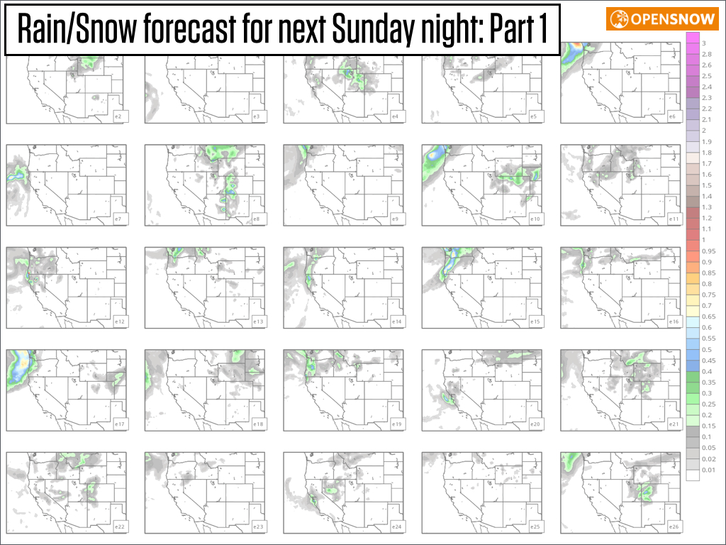
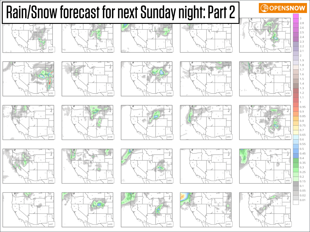
For example, here are 50 different precipitation forecasts for next Sunday night from the European model. The group that runs the model tweaks a few parts of the model (for example, the initial weather conditions fed into the model) and the result is 50 slightly different forecasts. If most of these forecasts are similar to one another, then there is high confidence in the forecast.
However, for the Sunday night storm, of the 50 different forecasts below, only about 15-20 show significant precipitation for Colorado while others show a slower storm (precipitation further west) or no storm at all. If the European model is only 30-40% confident of precipitation in the 5 day forecast, I'm going to wait to figure this storm out until there is more consistency.
Since the 5-day forecast is this uncertain, I don't think there's much we can figure out beyond that. Most models, including the European, hint at the chance for at least one more storm during the last week of October, but we likely won't be able to know the details until 3-4 days from now.
JOEL GRATZ
About Our Forecaster
Joel Gratz
Founding Meteorologist
Joel Gratz is the Founding Meteorologist of OpenSnow and has lived in Boulder, Colorado since 2003. Before moving to Colorado, he spent his childhood as a (not very fast) ski racer in eastern Pennsylvania.
Free OpenSnow App


