Colorado Daily Snow

By Joel Gratz, Founding Meteorologist Posted 11 years ago October 24, 2012
Finally, finally, finally...we're within 12 hours of seeing good snow in Colorado. It's been almost 10 days since I started talking about this storm, and watching three feet of snow hit Alpine Meadows (Lake Tahoe area), nearly two feet hit the mountains north of Salt Lake City (Utah), and about a foot in the Tetons (Wyoming) has made me a bit restless. But, the time has come and I have good news.
There are three parts to Elvira (the storm), and the first part might be just a little more energetic than I thought, which means perhaps an extra inch or two of snow. Here's the breakdown.
Part one will arrive in northern Colorado (around Steamboat) by late afternoon and it should be snowing pretty heavily by sunset. This heavier snow band will move south and start the heavy snow for the I-70 mountains and along the continental divide to the north by 7-9pm. It'll then head south toward Aspen and bring a few hours of heavier snow there as well. Snow will fall to the valley bottoms, though the best accumulations (3-6 inches or so) will stay up on the ski areas and higher peaks. The snow will slow down to flurries and snow showers by late evening in the north and around midnight down toward Aspen. The urban areas on the plains will also see some flakes, but I don't think it'll be much more than an inch or two. Still, my snow tires are on:-)
Part two of Elvira is on Thursday which will be much drier than Wednesday night, but off-and-on snow squals and snow showers will hang out in the mountains from Aspen and I-70 and northward to the Wyoming border, and all of these areas could see another 1-2 inches with these showers.
Part three of Elvira is on Thursday night which will be focused on areas east of the divide and into the foothills and Palmer Divide (higher elevation areas south of Denver and north of Colorado Springs, near Castle Rock). This part of Elvira should once again bring the heaviest snow between about 6pm Thursday and midnight Thursday night, and there could be some nice totals in the eastern foothills where up to 6 inches could accumulate. For the rest of the mountains and ski areas, I only expect a continuation of snow showers with light accumulations. Areas closest to the divide (Winter Park, Loveland, Abasin) could see a bit more snow.
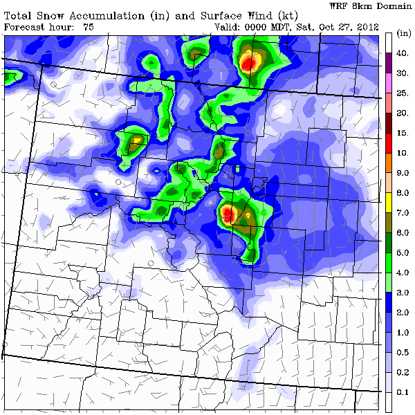
Here are Elvira's snow totals from Wednesday morning through Friday midday. I don't always completely agree with these computer-generated predictions (which is why my snow forecasts don't always match the graphics), but overall this gives a nice indication of where the heavier snow will fall.

The atmosphere dries out on Friday and through the weekend, though we could see a few snow showers around Steamboat and the northern divide around Cameron Pass from quickly-passing storms that stay to our north.
Looking faaaaar into the future, the next storm should arrive next next weekend, about November 2nd or 3rd.
JOEL GRATZ
About Our Forecaster


